This action was commenced by plaintiff Paul T. Lucier (Lucier) on July 12, 2013, seeking to confirm title, pursuant to G.L. c. 185, § 56A, to the unregistered portion of the property located at 40 Skaket Way in Brewster that consists of upland and salt meadow (Locus). Lucier seeks to establish his interest in the entire Locus through his record title. Lucier also seeks a declaration, pursuant to G.L. c. 231A, that defendants Ronald H. Deschamps and Barbara Ann Weber (Defendants) do not have any interest in the Locus. The Defendants have appeared and answered, objecting to Lucier's claim to the Locus on the grounds that they have title to the upland portion of the Locus. The Town of Brewster also appeared and answered, objecting to Lucier's claim to the salt meadow portion of the Locus, east of the high water mark. Before trial, the Town withdrew its objections to Lucier's confirmation and entered a stipulation with Lucier that if confirmation is entered, it is subject to the Town's conservation restriction and easement.
For reasons more fully explained below, Lucier has demonstrated his title to the entirety of the Locus by a preponderance of the evidence and is entitled to confirm his title, subject to the stipulation entered with the Town.
PROCEDURAL HISTORY
Paul T. Lucier (Lucier) filed the complaint (Complaint) in this confirmation of title case on July 12, 2013, following the judgment entered in the Barnstable Superior Court in Paul T. Lucier v. Fidelity National Title Insurance Company, case no. BACV2010-00772. The title examination report was filed on January 28, 2014. Citation by publication was made in the Cape Cod Times on April 3, 2014. Barbara Ann Weber (Weber) filed her Answer on April 28, 2014 (Weber Answer). The Town of Brewster (the Town) filed its Answer and Objections on May 12, 2014 (Town Answer). On June 5, 2014, the Commonwealth filed its Answers and Objections. Ronald H. Deschamps (Deschamps) filed his Answer on June 11, 2014 (Deschamps Answer). On November 28, 2014, the court defaulted all defendants with potential interest in the property that failed to respond after receiving notice pursuant to Mass. R. Civ. P. 55 (a). [Note 1] Cape Cod Five Cents Savings Bank was dismissed without prejudice on December 5, 2014, after conveying its claimed interest in the subject property.
On June 16, 2015, Lucier filed Plaintiff's Motion for Summary Judgment, Memorandum in Support of Plaintiff's Motion for Summary Judgment, Plaintiff's Concise Statement of Material Facts in Support of his Motion for Summary Judgment, Affidavit of Zachary W. Berk, Esq., and Plaintiff's Appendix. On July 17, 2015, Deschamps and Weber filed Defendants' Motion for Partial Summary Judgment (Deschamps and Weber's Cross-Motion for Partial Summary Judgment), Memorandum in Opposition to Plaintiff's Motion for Summary Judgment and in Support of Defendants' Cross-Motion for Partial Summary Judgment, Defendants' Response to Plaintiff's Concise Statement of Facts and Additional Alleged Undisputed Facts, and Defendants' Appendix. The same day, the Town filed Town of Brewster's Opposition to Petitioner's Motion for Summary Judgment, Town of Brewster's Response to Petitioner's Statement of Material Facts and Statement of Additional Material Facts, Affidavit of Sarah A. Turano-Flores in Support of Brewster's Opposition to Petitioner's Motion for Summary Judgment, Affidavit of Christopher Miller in Support of Town of Brewster's Opposition to Petitioner's Motion for Summary Judgment, and Brewster's Appendix in Support of the Opposition to Petitioner's Motion for Summary Judgment. On July 23, 2015, Lucier filed Plaintiff's Reply Concerning Defendants' Opposition to Plaintiff's Motion for Summary Judgment. On July 28, 2015, a hearing was held on Plaintiff's Motion for Summary Judgment.
On August 17, 2015, Lucier filed Plaintiff's Opposition to Defendants' Cross Motion for Summary Judgment, Plaintiff's Responses to Defendants' Statement of Additional Material Facts, and Plaintiff's Appendix. The same day, the Town filed Town of Brewster's Opposition to Cross-Motion for Summary Judgment by Respondents Ronald Deschamps and Barbara Ann Weber and Town of Brewster's Response to Respondent's Statement of Additional Material Facts. On August 20, 2015, the court issued a Memorandum and Order Denying Plaintiff's Motion for Summary Judgment (2015 Memorandum and Order). Defendants' Weber and Deschamps Reply Memorandum in Support of their Motion for Partial Summary Judgment and Affidavit of Peter S. Farber were filed on August 27, 2015. Deschamps' and Webers Cross-Motion for Partial Summary Judgment were heard on September 3, 2015. On July 11, 2016, the court issued a Memorandum and Order Denying Defendants' Cross-Motion for Partial Summary Judgment.
A Joint Pre-Trial Memorandum was filed on October 26, 2016. Plaintiff's Motion for Leave to File Amended Complaint was filed on October 31, 2016. A Pre-Trial Conference was held on November 1, 2016, where the parties agreed that this matter will not adjudicate any rights of the Commonwealth. On November 7, 2016, the Opposition to Plaintiff's Motion to File Amended Complaint, Defendants Weber and Deschamps Motion in Limine, and Defendants Weber and Deschamps Memorandum in Support of Motion in Limine were filed. On November 15, 2016, the court issued an Order on Plaintiff's Motion for Leave to File Amended Complaint. On November 29, 2016, the Town of Brewster's Opposition to Deschamps' and Weber's Motion in Limine and Plaintiff's Opposition to Defendants' Motion in Limine Concerning Declarations of Descendants were filed. A hearing on the Motions in Limine was held on December 2, 2016, where the court denied the Defendants' Motion in Limine Concerning Declarations of Descendants, finding that the "subject affidavits are declarations of deceased persons made in good faith and upon personal knowledge, and that statements of Willie Atwood set forth in affidavits are not presented for their truth but for evidence of Atwood's belief."
On December 5, 2016, the court deemed case no. 16 MISC 000720 a companion case to the registration case no. 13 REG 43480. A trial was held on January 24-26, 2017. A view was taken on January 26, 2017. Testimony was heard from Richard Golder, Kenneth B. Anderson, and Chester Lay. Exhibits 1-113 were marked. On January 24, 2017, the first day of trial, the Plaintiff and Town of Brewster reported settlement in principle. A stipulation was filed. The court heard and denied Defendants' Motion in Limine.
On April 19, 2017, Plaintiff Paul T. Lucier's Proposed Finding of Fact and Conclusions of Law was filed. On April 21, 2017, Defendants' Post-Trial Brief was filed. On May 4, 2017, Plaintiff's Motion to Strike New Exhibits Attached as the Addendum to Defendants' Post-Trial Brief and Testimony of Defendants' Counsel during the View was filed. On May 17, 2017, a Joint Motion of Petitioner and Defendant Town of Brewster for Approval of Stipulation and Withdrawal of Answer and Objection by Defendant Town of Brewster was filed. On May 31, 2017, a Stipulation and Withdrawal of Answer and Objection by the Defendant Town of Brewster and Defendants' Partial Opposition to Plaintiff's Motion to Strike Portions of Post-Trial Brief were filed. Closing arguments were heard on May 31, 2017, where the court allowed the Joint Motion of Petitioner and Defendants Town of Brewster for Approval of Stipulation and Withdrawal of Answer. The court also allowed in part Plaintiff's Motion, striking Addendums 1- 4, 8(a), and 8(b). The court then took the case under advisement. This Decision follows.
FACTS
Based on the view, the undisputed facts, the exhibits, the testimony at trial, and my assessment of credibility, I make the following findings of fact.
The Locus
1. The property at issue is located at 40 Skaket Way in Brewster (Property). The Property is on the Brewster/Orleans town line, abutting the Cape Cod Rail Trail bike path to the south (previously the Old Colony Railroad) and the Namskaket Creek to the east. Exh. 111, ¶¶ 2- 3; view.
2. The Property consists of two registered parcels and one unregistered parcel of land. Exh. 111, ¶ 3.
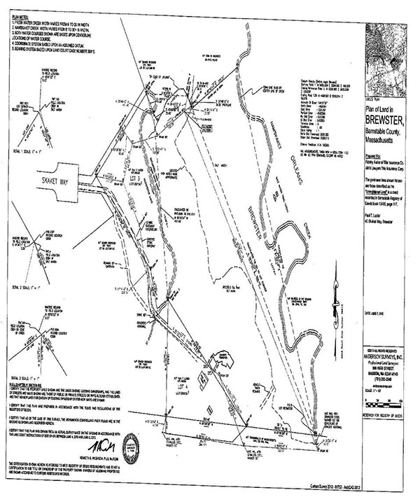
3. The area in dispute is the unregistered parcel (Locus) shown on a plan labeled "Plan of Land in Brewster, Barnstable County, Massachusetts," prepared by Anderson Surveyors, Inc. and dated June 7, 2013 (Anderson Plan), attached here as Exhibit A. The two registered parcels are also depicted on the Anderson Plan as Lots 3 and 4. Exh. 1.
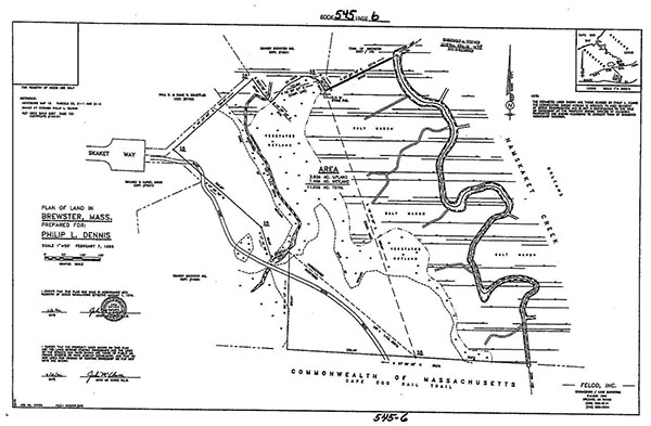
4. The Locus is also shown on a plan prepared by Felco, Inc., recorded in the Barnstable County Registry of Deeds (registry) on November 12, 1998, at Plan Book 545, Page 6 (Felco Plan), attached here as Exhibit B. Exh. 104.
5. The Locus is comprised of upland, vegetated wetland, and salt meadow. [Note 2] A high-water mark, running roughly north to south, divides the Locus. The salt marsh lies below the high-water mark, covering the eastern portion of the Locus. The upland and vegetated wetland area cover the western portion of the Locus, extending to a brook marking the western boundary. The salt marsh, vegetated wetland and upland are shown on the Felco Plan. Exh. 111, ¶ 4; Exh. 104.
6. The Locus does not contain any swampland. Tr. 1:152-153, 155-156; Tr. 2:83, 118-120; Tr. 3:52-57.
Old Colony Railroad Extension
7. The Old Colony Railroad, where the Cape Cod Rail Trail now exists, was extended through Brewster in the mid to late 19th Century. Tr. 2:142-143.
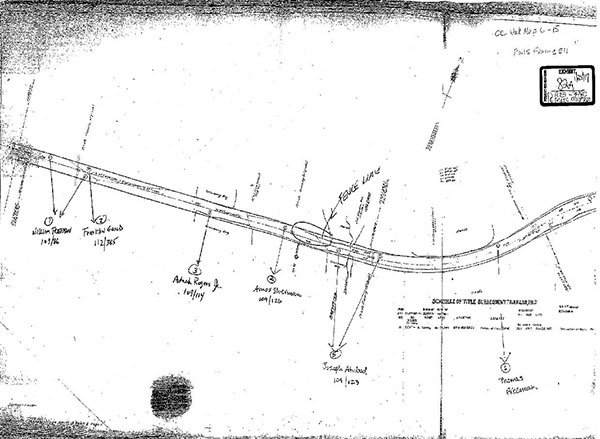
8. Abutting property owners whose land was needed for the construction of the new railroad conveyed a portion of their land to the Old Colony Railroad for monetary consideration. These abutting property owners included Joseph Atwood (Mary E. Atwood's father-in-law), William Freeman, Adnah Rodgers, Thomas Freeman, Amos Sherman, and Franklin Gould. Tr. 1:185-187; Exhs. 2, 83.
9. On April 22, 1864, Joseph Atwood conveyed a strip of his land to the Old Colony Railroad for consideration of $65.00 by deed recorded in the registry at Book 109, Page 123. This strip extended from Brewster into Orleans and was bounded "westerly by land now or formerly owned by Samuel Hurd." Tr. 1:76-77, 79, 159; Exh. 83.
10. A layout plan of the Old Colony Railroad was approved on April 9, 1878 (OCR Layout Plan). The OCR Layout Plan reflects a survey of the property used for the construction of the Old Colony Railroad extension, identifies the property owners abutting the tracks, and roughly depicts the location of their lines. Not all the distances on the OCR Layout Plan correspond with the distances stated in the deeds from the abutters to the Old Colony Railroad. Tr. 1:72-73, 76-78, 185; Tr. 2:73-74; Exh. 2.
11. The OCR Layout Plan identifies Joseph Atwood as the owner of the property to the north of the railroad tracks, west of Namskaket Creek and east of Samuel Hurd's property. Tr. 1:73-78, 94, 126-127; Exh. 2.
12. The OCR Layout Plan does not identify anyone by the name of Knowles or Eldredge as owners of property abutting the railroad tracks in the area of the Namskaket Creek, near the Brewster-Orleans town line, nor are there deeds from either a Knowles or Eldredge to the Old Colony Railroad. Tr. 1:77-78; Tr. 3:25-26; Exhs. 2, 83.
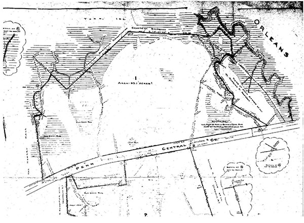
13. A railroad valuation plan from 1915 also depicts Joseph Atwood as a northerly abutter of the railroad tracks, west of the Namskaket Creek, and east of Amos Sherman's property, extending past the edge of the salt marsh (OCR Valuation Plan). The OCR Valuation Plan is attached here as Exhibit C. Tr. 1:191-192; Tr. 3:28; Exh. 82A.
14. Chester Lay (Lay) is a professional licensed surveyor with over 40 years of experience in surveying properties in and around Cape Cod. Lay testified that the absence of a deed to the Old Colony Railroad from someone named Knowles or Eldredge, and their lack of appearance on the OCR Layout Plan and OCR Valuation Plan, was not determinative of whether they owned property in the area of the Locus. Lay pointed out discrepancies between the distances in the deed descriptions and the distances shown on the OCR Layout Plan and stated that such inconsistencies made them unreliable. Lay theorized that Knowles or Eldredge could have owned property slightly above the boundary of the railroad and, therefore, the Old Colony Railroad would not have sought a deed from them since they were not direct abutters, nor would they be pictured on the OCR Layout Plan and OCR Valuation Plan. I do not credit Lay's testimony. Tr. 2:130, 156-161; Tr. 3:21-26; Exhs. 2, 82, 82A, 83.
15. Richard Golder (Golder) is an attorney and title examiner with over 40 years of experience working on title issues for properties primarily in Barnstable and Plymouth counties. Golder testified that the deed from Joseph Atwood to the Old Colony Railroad, and placement of Joseph Atwood on the OCR Layout Plan and OCR Valuation Plan, were strong indications that Joseph Atwood owned property on both sides of the railroad in the area of the Locus and across the Brewster-Orleans town line. Golder attested that it was significant to have the abutters' land depicted on the OCR Layout Plan since the abutters were paid for the portion of their properties sold. The purpose of the OCR Layout Plan was to clarify the actual layout for the railroad so that construction could begin and it was appropriate to be accurate. Golder stated that the distances on the OCR Layout Plan do not correspond to the distances in the abutters' deeds because the deeds were acquired in 1864 and 1873, prior to the layout plan being developed and approved in 1878. The deeds were a preliminary approach to get the conveyances of property for the railroad from the abutters. Golder stated that the Old Colony Railroad made an effort to obtain fee interests in the abutting land through the deeds, but opined that the OCR Layout Plan was a more accurate depiction of the location of the abutters. Golder attested that because there was no deed from anyone named Knowles or Eldredge, and they are not shown on either the OCR Layout Plan or the OCR Valuation Plan, there is a presumption that they did not own any land abutting the railroad. I credit Golder's testimony. Tr. 1:54, 72-73, 76-77, 126-127, 188-192; Exhs. 2, 82, 82A, 83.
16. Kenneth B. Anderson (Anderson) is a professional licensed surveyor with over 40 years of experience surveying properties mainly in eastern Massachusetts and Cape Cod. Anderson testified that based on the deed from Atwood to the railroad, the OCR Layout Plan and OCR Valuation Plan, Joseph Atwood likely owned property north of the railroad and to the west of property owned by Samuel Hurd. Like Golder, Anderson also stated that the OCR Layout Plan was more helpful in determining the location of the property lines than using the deeds from the abutters that had errors in the distances. Anderson testified that he was able to use the stationing information and measurements from the OCR Layout Plan to plot the Hurd/Atwood property line, which is shown on the Anderson Plan. I credit Anderson's testimony. Tr. 2:57-59, 73-80; Exhs. 2, 82, 82A, 83.
17. Based on the testimony of Golder and Anderson, I find that the absence of Knowles and Eldredge from the OCR Layout Plan and OCR Valuation Plan, and the lack of a deed to the Old Colony Railroad, is evidence that no one named Knowles or Eldredge was an abutter to the railroad during this time. In contrast, Joseph Atwood did deed a portion of his land in the area of the Locus to the Old Colony Railroad. Atwood's appearance on both OCR Plans as a northerly abutter of the railroad, a westerly abutter of the Namskaket Creek, and an easterly abutter of property of Samuel Hurd, demonstrates the location of the property he owned at the time was in the area of the Locus.
Lucier's Chain of Title
18. Lucier claims to derive his title to the entire Locus from the deed of Laura A. Robbins, Herman F. Atwood, and Joseph Atwood to Mary E. Atwood dated April 12, 1886 and recorded in the registry at Book 190, Page 454 (Atwood Deed). Exh. 3.
19. The Atwood Deed conveys three parcels of land. It describes the third parcel of land to be conveyed as:
[A] lot of Salt meadow bounded on the West by upland of the heirs of Elijah Knowles. On the north by meadow of Josiah Foster. On the East by the Creek and on the South by the Old Colony Rail Road.
Exh. 3.
20. The northern, eastern, and southern boundaries of the property conveyed by the Atwood Deed are undisputed. Tr. 1:60-61; Tr. 2:224; Tr. 3:78.
a. The creek referenced in the Atwood Deed as the eastern boundary of the parcel conveyed to Mary E. Atwood is the Namskaket Creek, as shown on the Anderson Plan. Tr. 1:60-61; Tr. 3:70-71; Exh. 1.
b. The Old Colony Rail Road referenced in the Atwood Deed as the southern boundary of the parcel conveyed to Mary E. Atwood is now the Cape Cod Rail Trail bike path, as shown on the Anderson Plan. Tr. 1:58; Exh. 1.
c. Josiah Foster, whose meadow is referenced in the Atwood Deed as the northern boundary of the parcel conveyed to Mary E. Atwood, was conveyed a parcel of "salt and fresh meadow" in Brewster known as the "island piece" pursuant to a deed dated December 3, 1856, and recorded in the registry at Book 65, Page 373 (Foster Deed). The Foster Deed is bounded "northerly by Lincoln Foster to the creek and by the creek to the meadow of Joseph Atwood and on the south to the woods and by the woods to the land of Lincoln Foster." Tr. 1:60-61, 69-71; Tr. 2:184-185, 224; Tr. 3:70-71; Exh. 93.
21. The western boundary of the property conveyed to Mary E. Atwood by the Atwood Deed is "by upland of the heirs of Elijah Knowles." Exh. 3.
22. It is undisputed that the Atwood Deed conveyed at least the salt marsh portion of the Locus. Tr. 2:6; Tr. 3:79; Exh. 3.
23. The Atwood Deed describes the land conveyed in general terms as "a lot of salt meadow," but does not state that the salt meadow is a boundary or that the property extends only to the "edge of" salt meadow or "edge of" upland of the heirs of Elijah Knowles. Tr. 1:63-64; Tr. 2:105; Exh. 3.
24. Lay testified that the reference to "a lot of salt meadow" in the Atwood Deed meant that it only conveyed a parcel of salt meadow. He testified that while a conveyance of salt meadow was determinative as to the type of land conveyed, a conveyance of "a lot of swamp wood" could include an upland area. Lay did not explain why land described as "salt meadow" can only mean a salt meadow itself, but land described as "swamp" could also include upland, other than by stating that he had not come across such a deed. I do not credit Lay's conclusion. Tr. 2:185-188; Tr. 3:58-59, 76-77.
25. Golder testified that the Atwood Deed conveyed the entire Locus, including upland. Golder did not believe that the use of the phrase "a lot of salt meadow" restricted the conveyance to exclusively the salt marsh. During this time period, Cape Cod was sparsely populated and, thus, Cape Cod deeds contained less precise "country descriptions" as opposed to deeds recorded in more urban areas. Golder testified that at the time of the Atwood Deed conveyance, it was common to describe property as extending to "the edge of" a particular type of land (such as upland or meadow) when there was an intent to identify a boundary with specificity. Salt hay, which was harvested from salt meadow, was a valuable commodity in 19th Century Cape Cod. It was important to identify a salt meadow being conveyed, regardless of whether a parcel conveyed other kinds of land, because the property would have been owned primarily for the purpose of harvesting salt hay. Further, Golder testified that a conveyance of salt meadow would require adjacent upland to be included to provide access to the area by wagon in order to harvest, load and transport the salt hay. In this case, Golder stated that the salt marsh portion of the Locus would not have been accessible to harvest salt hay without the use of the adjacent upland area of the Locus because the only other means of access would be by boat from Orleans across Namskaket Creek. I credit Golder's testimony. Tr. 1:50-54, 61, 63-65, 77, 101-103, 108-109, 115-116, 122-123, 174-175, 177-178; Exhs. 3, 76.
26. Anderson agreed with Golder's opinion that the Atwood Deed conveyed both the upland and the salt meadow. Anderson testified that the reference to "a lot of salt meadow" did not mean that the parcel could not contain upland. Anderson stated that he has reviewed many deeds from the 19th Century which frequently used the term "by the edge of" to specifically delineate the boundaries of a parcel, a term that was not present in the Atwood Deed. Like Golder, Anderson also based his opinion on the fact that if the Atwood Deed did not convey any upland, there would be no access to the salt meadow to harvest the salt hay. He stated that the description in the Atwood Deed was similar to other deeds of lots of cranberry bogs on Cape Cod, which would refer to a parcel as "a lot of swamp wood," but would clearly include portions of the upland to provide access to harvest the cranberry bog. I credit Anderson's testimony. Tr. 2:57-59, 68-72, 105; Exhs. 3, 90-91.
27. At the time of the Atwood Deed, there was an old cart path located along what is now the southwestern boundary of the Locus and northeastern boundary of Lot 4, as shown on the Anderson Plan. The cart path provided wagons with convenient access to the upland portion of the Locus adjacent to the salt meadow for purposes of harvesting salt hay. Mary E. Atwood's heirs used the cart path to access the Locus for this reason. Based on the testimony of Golder and Anderson, which I credit, and the existence of the cart path leading to the upland portion of the Locus, I find that the Atwood Deed description of "a lot of salt meadow" did not limit the conveyance to only the salt meadow, but included the upland portion of the Locus to provide a means of access to harvest the salt hay. Tr. 1:65-67, 86-89, 115-116, 122-123; Tr. 2:72-73; Exhs. 1, 27-29, 62, 108.
28. Following the death of Mary E. Atwood on October 14, 1923, who died intestate, her property passed to six heirs: Willie D. Atwood, Ruth Chase, Clarence Kelley, Nellie L. Kelley, Bernice Snider, and Mildred S. Hurley. Tr. 1:131; Exh. 9.
29. On October 1, 1924, the heirs of Mary E. Atwood conveyed their interest in all of Mary E. Atwood's property, including the Locus, to Willie D. Atwood, her son, by deed recorded in the registry at Book 410, Page 38. Tr. 1:107, 131; Exh. 10.
30. Between 1922 and 1946, Willie D. Atwood's grandniece, Madeline Armeson, traveled with him by horse and wagon to the area of the Locus in order to farm salt hay. The salt hay was removed from the salt meadow, dried on large drying racks, and then loaded onto wagons in large quantities for transportation. Tr. 1:115-116; Exh. 28.
31. In a conversation with Madeline Armeson, Willie D. Atwood claimed ownership to the land on "both sides of the creek," including the entirety of the Locus, "as far as the eye could see." Tr. 1:116; Exhs. 24, 28.
32. Raymond Nichols (Nichols), a resident of Orleans who had worked as a fur trapper in East Brewster and around Namskaket Creek, attested that Willie Atwood expressed to him that Namskaket Creek was the eastern boundary of his property and permitted Nichols to keep a rowboat at Namskaket Creek. During the 1920s and 1930s, Nichols observed Willie D. Atwood cutting wood and salt hay in the area of the Locus for more than a decade. Tr. 1:117- 118; Exh. 29.
33. Following the death of Willie D. Atwood on April 20, 1946, his will specifically devised parcels of land. Willie D. Atwood left a piece of land in Brewster known as the "neck piece" to his grandnieces Audrey Nickerson and Ellen Holmes, which was bounded "on the south by the railroad, on the east by land of Elnathan E. Eldredge, on the north by meadow and heirs of Francis Freeman, and on the west by land of George E. Lee." The land of Elnathan Eldredge included the area known as the Maple Spring Bog. Willie D. Atwood left the remainder of his real estate, including the Locus, to his wife Julia A. Atwood. Tr. 1:107, 132-133; Exhs. 11- 12.
34. On November 22, 1947, Julia A. Atwood passed away with a will, leaving all of her property, including the Locus, to be divided equally between her nieces and nephews: Zella Wilmot, Alvin W. Bearse, Madeline P. Dunford aka Madeline P. Armeson (Armeson), [Note 3] Marion L. Kendrick (Kendrick), and Henry W. Bearse. Each heir retained a 1/5 interest in the Locus.
The estate of Julia A. Atwood was not initially probated following her death and the proceeds from the estate were not timely distributed to her heirs. Tr. 1:135-138; Exhs. 13, 13A.
35. Richard Nickerson (Nickerson), who was married to Willie D. Atwood's grandniece, Audrey Nickerson, visited the area of the Locus in 1947 with Elnathan E. Eldredge, the then owner of the Maple Spring Bog, who pointed out the boundaries of Willie Atwood's property that included the entirety of the Locus. In 1948, Nickerson visited the area with a surveyor, Eldredge Sparrow, and showed him the boundaries of Willie D. Atwood's property. Sparrow drafted the plan later submitted for registration of the Property, which depicted the Locus as being owned by the "Heirs of Julia A. Atwood et. al. c/o Madeline P. Armeson." Tr. 1:118-119; Exhs. 24, 30.
36. On March 22, 1958, Elnathan E. Eldredge conveyed a large parcel of land west of the Locus that encompassed the Maple Spring Bog to Frank Joy Inc. by deed recorded in the registry at Book 773, Page 331. Tr. 1:105-106; Exh. 15.
37. Alvin W. Bearse, nephew of Julia A. Atwood, died intestate on February 21, 1964. The administrator of his estate was his son, David G. Bearse. Tr. 1:139-140; Exh. 16.
38. Henry W. Bearse, grandnephew of Julia A. Atwood, died intestate on February 27, 1965. The administrator of his estate was his wife, Wilhelmina D. Bearse. Henry W. Bearse's estate was divided among his wife and his six surviving children. Tr. 1:140; Exh. 21.
39. On March 24, 1967, the heirs of Zella Wilmot, niece of Julia A. Atwood, conveyed "all of that land in the County of Barnstable, Massachusetts, formerly owned by Julia A. Atwood of Orleans, consisting of all land of whatever nature or wherever located in said County, or any rights therein" to Kendrick and Armeson by deed recorded in the registry at Book 1363, Page 936. Tr. 1:141, 147-148; Exh. 17.
40. On August 13, 1968, David G. Bearse obtained a license from the Probate Court to sell Alvin W. Bearse's interest from the estate of Julia A. Atwood. David G. Bearse, as administrator for the estate of Alvin W. Bearse, conveyed "all right, title, and interest to any other land in Brewster and Orleans, formerly part of the estate of Julia A. Atwood" to Kendrick and Armeson by deed dated August 20, 1968, and recorded in the registry at Book 1411, Page 18. Tr. 1:139-140; Exhs. 16, 18.
41. The same day, August 20, 1968, Kendrick and Armeson conveyed "any right, title, and interest to any other land in Brewster and Orleans formerly part of the estate of Julia A. Atwood" to David G. Bearse and Wilhelmina D. Bearse, widow of Henry W. Bearse, by deed recorded in the registry at Book 1411, Page 19. Tr. 1:141-142; Exh. 19.
42. On August 21, 1968, David G. Bearse conveyed "all of [his] right, title, and interest in . . . land from the estate of Julia A. Atwood" to Armeson by deed recorded on March 21, 1974 in the registry at Book 2016, Page 179. Wilhelmina D. Bearse still retained her deeded interest in the estate of Julia A. Atwood. Tr. 1:142; Exh. 20.
43. On December 9, 1968, Frank Joy Inc. conveyed the parcel he obtained from Elnathan E. Eldredge of land west of the Locus encompassing the Maple Spring Bog to Tonn, Inc. (Tonn) by deed recorded in the registry at Book 1438, Page 462. Exh. 22.
44. On January 13, 1971, Tonn, Inc. filed a Petition for Registration to register two parcels of land acquired through the deed from Frank Joy Inc., identified as Lots 1 and 2 on a "Plan of Land in Brewster" dated September 1970 (1970 Plan) in registration case no. 36915 (First Registration Case). On the 1970 Plan, Lots 1 and 2 are located west of the Locus, identified on said plan as property of "Heirs of Julia A. Atwood et al. c/o Madeline Armeson." The 1970 Plan is attached here as Exhibit D. Exh. 111, ¶ 5; Exhs. 23-26.
45. In connection with the First Registration Case, Tonn submitted several affidavits seeking to establish that its predecessor in interest, Willie Atwood, had obtained title to Lot 1 by adverse possession. These included affidavits by Armeson, Nichols, and Nickerson. Tr. 1:113- 119; Exhs. 28-30.
46. Armeson answered and objected to Tonn's petition alleging that "the petition seeks to include a portion of the land belonging to the heirs of Julia Atwood." Armeson and Tonn reached a stipulation that resulted in Tonn conveying to Armeson rights to two triangular parcels of land located within Lot 1, shown as Lots 3 and 4 on the Anderson Plan and Felco Plan. Exhs. 27-28, 31.
47. On October 26, 1976, the Court entered two orders confirming and registering the remainder of Lot 1 and Lot 2 in favor of Tonn, and Lots 3 and 4 in favor of Armeson. These registered parcels abut the Locus, but are not the subject of this confirmation action. Exhs. 32-33.
48. On August 23, 1977, Armeson petitioned the Probate Court to be the administratrix of the estate of Julia A. Atwood since the assets were never fully administered and the prior executors were either deceased or assented. Tr. 1:143; Exh. 13.
49. On May 5, 1980, Armeson conveyed all her interest in the estate of Julia A. Atwood to David G. Bearse by deed recorded in the registry at Book 3106, Page 344. Tr. 1:143; Exh. 35.
50. On September 26, 1988, Armeson, as administratrix of the will annexed of the estate of Julia A. Atwood, conveyed the Locus to herself, individually, by deed recorded on October 13, 1988 in the registry at Book 6478, Page 306 (Armeson Deed). The Armeson Deed describes the Locus as being bounded northeasterly by Namskaket Creek, southerly by the Cape Cod Rail Trail, southwesterly by Lot 4, westerly and southwesterly by Lot 3 and Lot 1, and northerly by land now or formerly of Tonn, containing 12.3 acres more or less. The remaining interests in the Locus inherited from the estate of Julia A. Atwood, were subsequently conveyed to Armeson. Tr. 1:143-144, 146; Exh. 36.
51. On July 12, 1990, David G. Bearse and Kendrick conveyed their interest in the Locus using the metes and bounds description from the Armeson Deed to Armeson by deed recorded on November 6, 1992 in the registry at Book 8293, Page 36. Tr. 1:146; Exh. 37.
52. On May 21, 1993, Wilhemina D. Bearse and other heirs of Henry W. Bearse conveyed their interest in the Locus using the metes and bounds description from the Armeson Deed to Armeson by deed recorded in the registry at Book 8587, Page 100. Tr. 1:147; Exh. 38.
53. On May 21, 1993, after acquiring the interest in the Locus from all the heirs of the estate of Julia A. Atwood, Armeson conveyed the Locus and the registered Lots 3 and 4 to Phillip L. Dennis (Dennis) by deed recorded in the registry at Book 8587, Page 103. Tr. 1:148; Exh. 39.
54. On June 6, 2001, Dennis conveyed the Locus, Lot 3, and Lot 4 to Kim Woodbury, Trustee of the Blarney Castle Trust by deed recorded on June 12, 2001 in the registry at Book 13927, Page 146. Tr. 1:148-149; Exh. 40.
55. On May 3, 2002, Kim Woodbury, Trustee of the Blarney Castle Trust conveyed the Locus, Lot 3, and Lot 4 to Mehdi Hosseini and Kim Woodbury, husband and wife, by deed recorded in the registry at Book 15125, Page 29. Tr. 1:149; Exh. 41.
56. The same day, May 3, 2002, Mehdi Hosseini and Kim Woodbury conveyed the Locus, Lot 3, and Lot 4 back to Kim Woodbury, Trustee of the Blarney Castle Trust by deed recorded in the registry at Book 15125, Page 51. Tr. 1:149; Exh. 42.
57. On August 12, 2002, Kim Woodbury, Trustee of the Blarney Castle Trust conveyed the Locus, Lot 3, and Lot 4 to Lucier by deed recorded in the registry at Book 15465, Page 117. Tr. 1:149; Exh. 43.
58. Armeson, Dennis, and Lucier all sought permits from the Town of Brewster between 1989 and 2004, claiming ownership of the Locus and seeking permission to build on the land. The Town issued several permits for construction on the Locus. Exhs. 46-55.
59. In 2008, Lucier began construction of a single family home on the upland portion of the Locus, which he now resides in. Exh. 111, ¶ 9.
60. Since at least 1970, owners of the property conveyed through the Atwood Deed were assessed taxes on the entire Locus. Exhs. 26, 55.
Defendants' Chain of Title
61. On December 7, 1847, Blossom Rodgers conveyed "a lot of upland and swamp" in Brewster to Samuel Hurd by deed recorded in the registry at Book 46, Page 346 (Hurd Deed). The Hurd Deed describes the property as follows:
A lot of upland and swamp situated in Brewster containing five acres more or less and bounded as follows: beginning at stake on the upland, which is the northwest corner bound of Joseph Atwood's lot, bought of Elijah Knowles, administrator, thence westerly on a straight line by land and swamp of Nathaniel Gould to a stake near a large swamp woods tree by a brook. Thence northerly by said brook to the center of an old cart way leading from the lower field so-called, thence southeasterly by said cart way and across the neck in the range of swamplands sold by said Knowles, administrator, to a stake near the edge of the meadow, thence by said meadow to Joseph Atwood's bound, westerly in said Joseph's range [to] the first mentioned bounds. Said premises are the same that Solomon Freeman, guardian to Margaret Freeman, conveyed to me
(emphasis added). No deed could be located from the administrator of the estate of Elijah Knowles. The property conveyed abuts the Locus to the southwest and was part of a parcel known as the Maple Spring Bog. This parcel was later bisected by the Old Colony Railroad, resulting in triangular-shaped piece of land north of the railroad and a rectangular-shaped piece of land south of the railroad. The portion north of the railroad is roughly the same triangular parcel that was later registered as Lot 4. Tr. 1:193-194; Exhs. 24, 60, 85.
62. On June 2, 1862, Elijah Knowles conveyed "a lot of woodland and swamp" to Elijah E. Knowles by deed recorded in the registry at Book 75, Page 239 (1862 Deed). The 1862 Deed describes the lot as "bounded on the east by meadow, on the south and west by land of Samuel L. Hurd and Franklin Hurd, containing 6 acres all situated in Brewster." The 1862 Deed does not mention a northerly abutter, the creek, or the railroad. Exh. 95.
63. On March 30, 1865, Elijah E. Knowles conveyed the same "lot of woodland and swamp" as in the 1862 Deed to Abigail Knowles by deed recorded in the registry at Book 85, Page 490 (1865 Deed). The 1865 Deed is also described as "bounded on the east by meadow, on the south and west by land of Samuel L. Hurd and Franklin Hurd, containing 6 acres all situated in Brewster." The 1865 Deed does not mention a northerly abutter, the creek, or the railroad. Exh. 96.
64. On February 24, 1872, Amos Sherman conveyed the same "lot of upland and swamp" in Brewster as in the Hurd Deed to Jonathan Sherman (Hurd/Sherman parcel) by deed recorded in the registry at Book 113, Page 315 (Sherman Deed). The description of the property line abutting the Locus in the Sherman Deed differs slight from the description in the Hurd Deed. The description in the Hurd Deed states that it runs "southeasterly by said cart way and across the neck in the range of swamplands sold by said Knowles, administrator," while the Sherman Deed states the bound continues "Easterly by said Cartway and across the neck in the range of the land of Elijah Knowles." There is no intervening deed conveying the Hurd/Sherman parcel from Samuel Hurd to Amos Sherman. Tr. 1:79-81, 89-92, 194-195; Tr. 2:28-30, 136-137; Exhs. 85-86.
65. On December 13, 1881, Elijah Knowles conveyed a parcel of land to Elijah E. Knowles by deed recorded in the registry at Book 146, Page 276 (1881 Deed). The 1881 Deed describes the parcel being conveyed as:
For the benefit of Alpheus Knowles of said Brewster, if he should need the same for his support and maintenance, the following described real estate in said Brewster, bounded on the north by Elijah Knowles, on the east by Elijah Knowles, William Lee and Samuel B. Hopkins, on the south by Old Colony Railroad, on the west by the land of Francis Baker.
Exh. 112.
66. On February 16, 1887, Abigail Knowles conveyed a parcel of land to David Atwood by deed recorded in the registry at Book 208, Page 225 (1887 Deed). The 1887 Deed describes the parcel being conveyed as:
A certain piece of upland and swamp situated in Brewster and bounded and described as follows: Commencing at the southeast corner of swamp of Samuel B. Hopkins heirs, thence westerly by the Old Colony Railroad and swamp of Jesse Doane to stake and stones, thence northerly by heirs of Francis Baker and others to the meadow, thence by the meadow of Franklin Gould and others to range of said Knowles and William Lee, thence by the swamp of said Lee and Samuel B. Hopkins to the first mentioned bound. Containing 15 acres more or less.
The Land Court examiner in the First Registration Case placed this parcel immediately to the west of the northerly portion of the brook and Locus, extending westerly and southerly around the Maple Spring Bog, and continuing southerly to the railroad. Exhs. 6, 60.
67. The Defendants claim to derive their title to the upland portion of the Locus by deed from the heirs of Elijah Knowles to Abner Eldredge dated January 6, 1894, recorded in the registry at Book 209, Page 436 (Eldredge Deed). The Eldridge Deed conveyed seven parcels of land in the area of the Namskaket Creek and describes the second parcel of land to be conveyed as:
One piece of swamp land: Beginning at a stake in N.W. Corner; Bounded on the north by salt marsh, east by Rail road, south and west by woodland of Amos Sherman and upland of David Atwood. 2 acres more or less.
The other six parcels conveyed by the Eldredge Deed were located south of the Old Colony Railroad. Tr. 1:150-151; Exh. 5.
68. The description contained in the Eldredge Deed is a hybrid of a bounded and a running description. The Eldredge Deed mistakenly locates the railroad to the east, which is impossible since the railroad runs east to west, and mistakenly locates the salt marsh to the north, when the salt marsh runs north to south. The Eldredge Deed does not specifically identify who, Amos Sherman or David Atwood, was located south of the parcel and who was located west of the parcel. It was not accurate for the Eldredge Deed to name Amos Sherman as an abutter in 1894, since he conveyed his interest in the abutting parcel to Jonathan Sherman in 1872, who passed away in 1873, and by 1894 Jonathan Sherman's estate had been transferred to Eliza Harding. Tr. 1:61, 151-152; Tr. 3:46-47, 49-51, 81; Exhs. 1, 5, 88.
69. Lay testified that the description in the Eldredge Deed is "a very poor description" and acknowledged that it is defective on its face. Lay opined that the land now described as "vegetated wetland" on the upland portion of the Locus, might have been called "swamp" in the late 19th Century. Lay's opinion ran contrary to his prior trial testimony and his affidavit where he stated that land now described as "vegetated wetland" would have been called upland in the late 19th Century. He also acknowledged that the land south of the Cape Cod Rail Trail and Locus is at a much lower elevation than the land north of the Rail Trail and has been described as a bog or swamp. Lay testified that one would need to speculate as to what the description in the Eldredge Deed meant. Lay recommended rotating the deed description by 90 degrees to more accurately describe the upland portion of the Locus, i.e., so that it would describe the property as bounded "on the east by salt marsh, south by Railroad, north and west by woodland of Amos Sherman and upland David Atwood." Lay noted that transcription errors are more common in deeds than errors that require entire parcels to be rotated. He stated it would be a "rare" occurrence to have to rotate a deed description to make it fit the realities of a parcel's location, but he has seen it before. He stated that he would also need to make an assumption as to who, Amos Sherman or David Atwood, was located west of the parcel and who was located south of the parcel. Lay suggested that the Eldredge Deed may have borrowed the Amos Sherman abutter description from an earlier deed, but mixed that old description with a newer description with regard to the reference to David Atwood who obtained land abutting the Locus to the northwest in 1887. I do not credit Lay's testimony. Tr. 2:52-53, 235-240; Tr. 3:46-57, 60-62, 81-82.
70. Golder and Anderson testified that the description in the Eldredge Deed was too incomprehensible to locate the parcel with any accuracy, but it more accurately describes land south of the Old Colony Railroad. Anderson testified that "swamp" refers to land that has standing water on it. Golder and Anderson testified that the terms "swamp" and "bog" are sometimes used interchangeably and that swamps can be converted into cranberry bogs. The upland portion that abuts the Cape Cod Rail Trail has an elevation of approximately 24 feet above sea level and is very dry. Golder and Anderson testified that the upland portion of the Locus does not contain any land that can be described as swamp or that would have been described as swamp in the late 19th Century. The term "vegetated wetland" is a more recent term that came about after the Wetlands Protection Act was enacted; such an area would have been considered upland in the 19th Century. Rather, they testified, the land south of the Locus and the Cape Cod Rail Trail is much lower in elevation and can be, and has been, described as a bog and swamp. Golder and Anderson attested that swapping the references to the "north" and to the "east" in the Eldredge Deed so that it read "on the north by Railroad, east by salt marsh," would put the parcel south of the railroad in the area of the swamp. They noted that the abutter calls referenced in the Eldredge Deed fit with the parcel in this location since both Amos Sherman and David Atwood owned land south of the railroad. This is also consistent with the other six parcels conveyed in the Eldredge Deed, which were all located south of the Old Colony Railroad. I credit Golder and Anderson's testimony and find that the references to the "north" and to the "east" in the Eldredge Deed were incorrect and should be swapped, placing the second parcel conveyed by the Eldredge Deed south of the Old Colony Railroad in the area of the swamp along the Brewster/Orleans town line. Tr. 1:59-60, 108-109, 151-160; Tr. 2:80-83, 85-88, 118-120.
71. Lay relied on the Hurd Deed and Sherman Deed to bolster his opinion that the Eldredge Deed conveyed the upland portion of the Locus. Lay testified that the conveyances of the Hurd/Sherman parcel identified Elijah Knowles as an abutter in the location of the Locus. He stated that the northeast bound of the Hurd/Sherman parcel followed the old cart path that existed west of the Locus (near the hypotenuse of what is now Lot 4) and then diverted from the cart path "across the neck" over to the salt meadow north of the Old Colony Railroad. Lay ignored the reference to "swamp" in the Hurd Deed in locating the boundary of the Hurd/Sherman parcel north of the railroad. In connection with his testimony at a previous trial, Lay created a sketch showing the boundary of the Hurd/Sherman parcel going "across the neck" from the cart path to the salt marsh in a location north of the Old Colony Railroad, across the most elevated upland on the Locus where there is no swamp, and labeling it as "line not determined" (Original Lay Sketch). Lay stated that this location helped explain why Elijah Knowles was not depicted on the Railroad Plan as an abutter. He created the Original Lay Sketch before he identified the Eldredge Deed as conveying the upland portion of the Locus. After identifying the Eldredge Deed, Lay moved the location of the northeast boundary of the Hurd/Sherman parcel to along the tracks, north of the railroad to make it consistent with his opinion that the Eldredge Deed conveyed the upland portion of the Locus abutting the railroad. Tr. 2:143, 152-154, 222; Tr. 3:8-11, 23; Exhs. 85-86; Chalk F.
72. Lay created a new sketch for purposes of this trial that depicts the northeast boundary of the Hurd/Sherman parcel as extending from the cart path to the salt marsh precisely along the Old Colony Railroad (New Lay Sketch). This boundary line in the New Lay Sketch is no longer labeled "line not determined." According to Lay, this new location of the boundary helps identify Elijah Knowles as the owner of the upland north of the railroad. Lay acknowledged that the Hurd Deed and the Sherman Deed did not describe the location of the "range of land of Elijah Knowles" relative to the "stake at the edge of the meadow." Lay testified that the location of the northeast boundary of the Hurd/Sherman parcel on the New Lay Sketch was speculation, but had been located with "better approximation" than in the Original Lay Sketch. Lay relied on the location of a fence line shown in the 1915 OCR Valuation Plan that ran along the tracks to confirm where he had located the northeast boundary of the Hurd/Sherman parcel. I do not credit Lay's testimony as to the location of the boundary "across the neck" of the Hurd/Sherman parcel. Tr. 2:131-132, 143, 222-223, 226-227; Tr. 3:12, 14-15, 17, 19-21, 31-34, 125; Chalk E.
73. I do not credit Lay's testimony as to the location of the boundary "across the neck" of the Hurd/Sherman parcel. There is no swamp north of the railroad where Lay placed the eastern boundary of the parcel and it is not clear where the land of Elijah Knowles is located relative to this boundary, or if the land was even still owned by Elijah Knowles or sold by the administrator of his estate. Lay stated that if the boundary of the Hurd/Sherman parcel went across from the cart path to the salt marsh in the location where the cart path most closely approached the swamp, then the Knowles property referenced would be located south of the railroad. There was no railroad at the time the parcel was conveyed in 1847 and neither deed conveying the Hurd/Sherman parcel referenced a fence or the railroad. Lay acknowledged that locating the boundary along the fence was arbitrary and that the fence may not have even existed at the time of the 1847 conveyance. Tr. 3:17-23, 30-34.
74. Golder testified that although the location of the Hurd/Sherman parcel's northeastern boundary from the cart path to the salt meadow could not be determined with accuracy, it likely ran south of the Old Colony Railroad. The swamp is located south of the railroad and the OCR Layout Plan shows Hurd's boundary line extending south of the railroad tracks. I credit Golder's testimony and find that the location of the eastern boundary of the Hurd/Sherman parcel followed the old cart path southeasterly below the railroad to the area of the swamp, as shown on the Anderson Plan, and then extended to the meadow owned by Joseph Atwood along the Brewster/Orleans town line. This places the rectangular-shaped portion of the Hurd/Sherman parcel below the railroad to the west of the old cart path. This placement fits with the Eldredge Deed conveying property also located south of the railroad and east of the old cart path, adjacent to the rectangular southern portion of the Hurd/Sherman parcel. The location of these parcels corresponds with the abutter calls used in the Eldredge Deed (south and west by land of Amos Sherman and David Atwood), and the abutter call used in the Hurd and Sherman Deeds (in the range of land of Elijah Knowles). Locating the Eldredge parcel south of the railroad is consistent with the size of the property (two acres) conveyed in the Eldredge Deed and the fact that all of the other parcels referenced in the Eldredge Deed could be located south of the Old Colony Railroad. Tr. 1:86-87, 89-90, 151, 152-155, 159-160; Tr. 2:81-82; Tr. 3:61-62; Exh. 2.
75. Lay testified that the 1862 Deed and 1865 Deed conveyed the upland portion of the Locus, the same parcel of land as described and conveyed in the Eldredge Deed. While Lay acknowledged that the term "meadow" mentioned in the 1862 Deed and 1865 Deed did not identify whether the meadow referenced was salt or fresh meadow, he attested that it likely referred to the salt meadow in the area adjacent to the Namskaket Creek. He also relied on the western abutter call of Samuel L. Hurd to confirm that the same parcel was conveyed in all three deeds. He could not find any records of property owned by Franklin Hurd in the area of the Locus. Lay recognized that Samuel Hurd did own other parcels of land in Brewster, in addition to the Hurd/Sherman parcel. Lay stated that he disregarded the word "swamp" used in the property descriptions in all three deeds. Although the 1862 Deed and 1865 Deed both conveyed a parcel of six acres, and the Eldredge Deed only conveyed a parcel of two acres, Lay opined that this was an inconsequential error since lot area has a low priority in establishing property boundaries. I do not credit Lay's testimony. Tr. 2:133-135, 190-192, 229; Tr. 3:36-40; Exhs. 5, 95-96.
76. Golder testified that the descriptions in the 1862 Deed and the 1865 Deed are so vague it is impossible to locate the parcel and rendering it impossible to tell whether those deeds conveyed the upland portion of the Locus that was supposedly later conveyed in the Eldredge Deed. He noted that the description of the parcel drastically changes between the 1862 and 1865 Deeds and the Eldredge Deed, particularly that the area of the parcel in the descriptions changed from six acres to two acres. Unlike Lay, Golder did not ignore the reference to "swamp" in the deeds, but concluded that the deeds could not have conveyed a parcel north of the railroad since swampland is only present south of the railroad. He noted that because the 1862 and 1865 Deeds only refer to being bounded by a "meadow," it is not clear if the deeds are referring to a salt or fresh meadow. Golder also found that Samuel Hurd owned several parcels of land in Brewster, including property south of the railroad. He could not find any records of property owned by Franklin Hurd. Golder opined that the 1862 and 1865 Deeds more likely described a parcel south of the railroad than in the upland area of the Locus. I credit Golder's testimony. Tr. 1:157-160; Tr. 2:52; Exhs. 5, 95-96.
77. I credit Golder's opinion that the descriptions in the 1862 Deed and the 1865 Deed are so vague that it is impossible to locate the property. Lay's opinion that the 1862 and 1865 Deeds conveyed the same parcel of land as the Eldredge Deed, the upland portion of the Locus, is not credible. Lay acknowledged that the Eldredge Deed and the earlier deeds had completely different property descriptions. Among other things, the 1862 and 1865 Deeds described six acres or woodland and swamp, and the Eldredge Deed only described two acres of swampland. The 1862 and 1865 Deeds described a meadow and the Eldredge Deed described a salt marsh. The 1862 and 1865 Deeds did not mention the creek, the railroad, David Atwood, or Amos Sherman, all references made in the Eldredge Deed. Golder, Anderson, and Lay were unable to locate any records of property in the area owned by Franklin Hurd. I find that the 1862 Deed and 1865 Deed did not convey the upland portion of the Locus.
78. Lay also based his opinion that the Eldredge Deed conveyed the upland portion of the Locus on the 1881 Deed and 1887 Deed. Lay testified that the 1881 Deed from Elijah Knowles to Elijah E. Knowles conveyed the same parcel of land as the 1887 Deed from Abigail Knowles to David Atwood. Lay located this property west of the brook, adjacent to the upland portion of the Locus. Based on the description in the 1881 Deed as bounded "on the east by Elijah Knowles," Lay determined that Elijah Knowles owned the property east of the brook, which includes the upland area of the Locus. I do not credit Lay's testimony that the 1881 and 1887 Deeds demonstrate that Elijah Knowles owned the upland portion of the Locus. Tr. 2:176- 177; Tr. 3:71-73, 107-114; Exhs. 6, 112.
79. Golder and Anderson testified that it was unclear whether the 1881 Deed and the 1887 Deed conveyed the same parcel. I credit their testimony. While some of the abutter calls are consistent between the two deeds, the descriptions differ enough that I cannot conclude that the two deeds conveyed the same property. The 1881 Deed does not state how many acres it is conveying, while the 1887 Deed provides that the property conveyed contains 15 acres more or less. The description of the bounds in the 1881 and 1887 Deeds do not mention the brook. Golder and Anderson testified that the description in the 1887 Deed from Abigail Knowles to David Atwood was not precise enough to locate relative to the Locus and contained several abutter calls that could not be verified. Golder noted that the Land Court examiner in the First Registration Case placed the parcel conveyed by the 1887 Deed in the same location as Lay, west of the brook. This was in the area that was disputed during the First Registration Case based on the objection of Armeson, a portion of which is now registered as Lot 3. If the property conveyed by the 1887 Deed was located in this area, Golder and Anderson testified, that would mean that Elijah Knowles owned land west of the upland portion of the Locus. This corresponds with the description from the Atwood Deed as being "bounded on the West by upland of the heirs of Elijah Knowles." Tr. 1:109-111; Tr. 2:40-50, 176-177; Exhs. 6, 112.
80. On March 5, 1903, Eliza Harding, heir of Jonathan Sherman who passed away in 1873, conveyed the Hurd/Sherman parcel to Charles Chase by deed recorded in the registry at Book 424, Page 318 (Chase Deed). The Chase Deed describes the parcel to be conveyed as:
A certain piece of swamp wood located in the town of Brewster, county and state as aforesaid, and is bounded as follows: on the north and east by land of David Atwood and the Skaket Cranberry Company, on the south by Gilbert Dodge, on the west by creek containing 4 acres, be the same more or less.
Though the Old Colony Railroad had been built by 1903, dividing the Hurd/Sherman parcel in two pieces north and south of the railroad, the Chase Deed does not mention the railroad as a bound and conveys the property as one parcel. Exhs. 87, 90.
81. By 1903, the Skaket Cranberry Company owned a parcel of land east of the rectangular piece of the Hurd/Sherman parcel and south of the railroad, pursuant to a deed from Eliza Harding to the Great Skaket Cranberry Bog Company dated July 28, 1892 and recorded in the registry at Book 201, Page 501. The deed describes the parcel as:
Commencing at the southwest corner of the premises at a bound of Gilbert A. Dodge and Mary E. Atwood and thence running northerly to a stake by the Old Colony Railroad, thence easterly by the railroad to a stake and stone by a ditch of said Great Skaket Cranberry Company, thence southerly by said ditch to a stake in the range of Mary Atwood, thence southwesterly by said Mary E. Atwood to the range first mentioned, containing ¼ of an acre be it the same more or less.
Tr. 3:63; Exh. 89.
82. On January 12, 1907, Charles Chase conveyed the Hurd/Sherman parcel to Solonois Childs by deed recorded in the registry at Book 282, Page 168 (Childs Deed). The Childs Deed describes the parcel to be conveyed as:
A certain piece of swamp and upland situated in the town of Brewster and bounded as follows: on the north by the Old Colony Railroad, on the east by upland of the Skaket Cranberry Company, on the south by land of Gilbert Dodge, on the west by a creek; also another piece of swamp and upland bounded by the following: on the east by woodland of Abner Eldredge, on the south by the Old Colony Railroad land, on the north and west by a creek. . . . the above described land is that which was deeded to Charles W. Chase by Eliza Harding of Orleans, on March 5, 1903, and those pieces together contain four acres of the same more or less.
While the Chase Deed describes David Atwood as the easterly abutter, the Childs Deed describes Abner Eldredge as the easterly abutter. This reference to Abner Eldredge as an easterly abutter in the Childs Deed was carried forward by subsequent deeds and plans. It was eventually changed in 1968 to identify Julia Atwood as the easterly abutter. Tr. 1:106-107; Exhs. 22, 91.
83. Lay testified that the Childs Deed's description of the parcel as being bounded on the east by Abner Eldredge is evidence that Eldredge owned the upland portion of the Locus northeast of the Hurd/Sherman parcel. I do not credit Lay's testimony. The Chase Deed stated that the land is bounded on the east by David Atwood. There is no deed between 1903 and 1907 from David Atwood to Abner Eldredge. Tr. 1:99-102; Tr. 2:183-184; Tr. 3:69-70; Exhs. 90-91.
84. In 1911, Arthur Sparrow plotted the area of the Maple Spring Bog using information from the Childs Deed, the most recent deed of record to the area. The plan was entitled "Plan of Swamp for Proposed Maple Spring Cranberry Bog, East Brewster, Mass., Surveyed & Mapped, Mar. 1911 by A. L. Sparrow, So. Orleans, Mass. Rough Swamp 8 Acres; Area Upland 11 ½ Acres; Completed Bog 4 ½ Acres; Total 24 Acres; Bought by Gerrish and Eldredge, Mar. 1909," (1911 Sparrow Plan). The 1911 Sparrow Plan showed Eldredge as the abutter to the northeast of the Hurd/Sherman parcel. Tr. 1:102-104, 108; Tr. 2:174-175; Exh. 72.
DISCUSSION
"The purpose of land registration proceedings under G.L. c. 185, 26-56A, is 'to provide a method for making titles to land certain and indefeasible.'" Lasell College v. Leonard, 32 Mass. App. Ct. 383 , 387 (1992), quoting McMullen v. Porch, 286 Mass. 383 , 388 (1934). "[T]he plaintiff in a registration petition must satisfy the Court with respect to (1) the legal basis of his or her claim of title to a particular parcel of land, and (2) the correct location of that land on the ground." Tyra v. Hall, 21 LCR 525 , 532 (2013), citing Kostorizos v. Samia, 9 LCR 117 , 119-120 (2001). In registration cases, the petitioners have the burden of proving they have title that is proper for registration. Hopkins v. Holcombe, 308 Mass. 54 , 56 (1941). The petitioner must prevail, if at all, on "the strength of his own title, and not upon the weakness" or nonexistence of the defendant's title. Butrick v. Tilton, 141 Mass. 93 , 96 (1886); Sheriff's Meadow Foundation, Inc. v. Bay-Courte Edgartown, Inc., 401 Mass. 267 , 269 (1987). "[P]ursuant to the provisions of G.L. c. 185, the plaintiffs bear the burden of establishing by a preponderance of the evidence that they hold title to the premises sought to be registered whether by matters of record or by adverse possession." Perkins v. Storkus, No. 41817, 123928, 1988 WL 1107856, at *4 (Mass. Land Ct. Nov. 16, 1988).
The petitioner is "entitled to registration of only the quantity of land to which he could establish his title." McCarthy v. Lane, 301 Mass. 125 , 129-130 (1938); see Harvey v. Inhabitants of Town of Sandwich, 256 Mass. 379 , 383 (1926). "The location on the ground today of what was described in a deed from the 1800s presents a question of fact . . . to be decided 'on all the evidence, including various surveys and plans.'" Bernier v. Fredette, 85 Mass. App. Ct. 265 , 268 (2014), quoting Hurlbut Rogers Mach. Co. v. Boston & Maine R.R., 235 Mass. 402 , 403 (1920); Baker v. Miller, 284 Mass. 217 , 222 (1933). "When presented with expert surveying and title testimony, a court must assess the opinions offered. The court must decide which . . . expert it finds more credible basing such assessment on the experts' analysis, taking into account the other evidence presented, including the documentary evidence, particularly the deeds and plans that lend support and corroboration to each opinion." Cytrynowski v. McDonald, 24 LCR 503 , 508 (2016), appeal pending, No. 2016-P-1450, quoting Lombard v. Cook, 20 LCR 325 , 326 (2012).
"Rules of deed construction provide a hierarchy of priorities for interpreting descriptions in a deed. Descriptions that refer to monuments control over those that use courses and distances; descriptions that refer to courses and distances control over those that use area; and descriptions by area seldom are a controlling factor. Moreover, when abutter calls are used to describe property, the land of an adjoining property owner is considered to be a monument." Paull v. Kelly, 62 Mass. App. Ct. 673 , 680 (2004). The court may consider "relevant extrinsic evidence bearing upon [the grantor's] intent, such as the circumstances with respect to the ownership of adjacent parcels, the contents of other instruments in the chair of title, and the subsequent action of the parties." Ellis v. Wingate, 338 Mass. 481 , 485 (1959). "Any competent evidence may be considered in determining the true boundary line between adjoining owners." Holmes v. Barrett, 269 Mass. 497 , 500 (1929). Ultimately, it is "for the judge to decide whether upon all the testimony and evidence it was more accurate to rely on one expert over another or ancient plans over more recent plans." Bernier, 85 Mass. App. Ct. at 268, citing Holmes, 269 Mass. at 502. "The law does not require absolute certainty of proof to determine a boundary line, but merely a preponderance of the evidence." Cytrynowski, 24 LCR at 508, citing McCarthy v. McDermott, 18 LCR 405 , 406 (2010).
The issue in this case is whether the Atwood Deed, the source deed relied on by Lucier, conveyed the entirety of the Locus or just the salt meadow portion, leaving the upland portion to be conveyed by the Eldredge Deed to the Defendants' predecessors in interest. The Atwood Deed recites three boundaries that are easily identifiable and undisputed by the parties: on the south by the Old Colony Railroad, on the east by the Namskaket Creek, and on the north by the meadow of Josiah Foster. The Old Colony Railroad, now the Cape Cod Rail Trail, and the Namskaket Creek are physical monuments that bound the Locus to the south and east, respectively. The parties' experts agree that the northerly abutter described in the Atwood Deed, the meadow of Josiah Foster, also referred to as the "island piece," was located at the northern boundary of the Locus. The location of the western boundary of the Atwood Deed, "by the upland of the heirs of Elijah Knowles," is the only boundary disputed by the parties.
It is undisputed that the Atwood Deed conveyed at least the salt marsh portion of the Locus. The Atwood Deed describes the land conveyed in general terms as "a lot of salt meadow." The Atwood Deed does not state that the salt meadow is a boundary or that the property extends only to the "edge of" salt meadow or by the "edge of" upland of heirs of Elijah Knowles. The use of the phrase "a lot of salt meadow" did not restrict the conveyance to exclusively the salt meadow, especially since it was common at that time to describe property as extending to the "edge of" a particular type of land (upland or meadow) when there was an intent to specifically delineate the boundaries of a parcel. Salt hay harvested from a salt meadow was a valuable commodity in Cape Cod during the 19th Century. It was important to identify when land contained a salt meadow, regardless of whether a parcel conveyed other kinds of land as well, because the property would have been owned primarily for harvesting salt hay. A conveyance of salt meadow would also require adjacent upland in order to provide access to the area by wagon to harvest, load, and transport the salt hay. The salt meadow of the Locus would not have been accessible to harvest salt hay without the use of the adjacent upland area of the Locus, since the only other means of access would have been by boat from Orleans across the Namskaket Creek.
The conclusion that the reference to "salt meadow" in the Atwood Deed does not set the western boundary of the land conveyed as the edge of the salt marsh is supported by other deeds in the record. It is undisputed that the Chase Deed and the Childs Deed conveyed the same parcel of land (a separate parcel from the Locus). The Chase Deed describes the land only as a piece of "swamp wood," but it is apparent from the later Childs Deed, which described the land as "swamp and upland," and the 1911 Sparrow Plan of the Maple Spring Bog, that the Chase Deed conveyed upland. This is true of deeds conveying cranberry bogs on Cape Cod during this time, which often referred to a parcel as "a lot of swamp," but would include upland portions to provide access to harvest the cranberries. While Lay agreed that land described as "swamp" could also include upland, he failed to explain why land described as "salt meadow" could not include any additional land besides the salt meadow. Lay's suggestion that the salt marsh portion could have been accessed by a boat from Orleans across the Namskaket Creek is not persuasive considering the overwhelming task of accessing the property this way, harvesting the salt hay, and making a return trip (or several) with a boat full of salt hay. It also does not comport with other evidence that salt hay was harvested using drying racks and transported from the Locus by wagon.
That the Atwood Deed conveyed the upland along with the salt meadow is further bolstered by the fact that at the time of the Atwood Deed conveyance there was an old cart path approximately located along what is now the southwestern boundary of the Locus and the eastern boundary of Lot 4. The cart path provided wagons with convenient access to the upland portion of the Locus adjacent to the salt meadow for purposes of harvesting salt hay. This is supported by several affidavits concerning Mary E. Atwood's son, Willie Atwood, and his use of the property in the area of the Locus for harvesting salt hay. Between 1922 and 1946, Willie Atwood and his grandniece, Armeson, traveled on the cart path by horse and wagon to the area of the Locus in order to farm salt hay from the meadow. The salt hay was removed from the salt meadow, dried on large drying racks, and then loaded onto wagons in large quantities for transportation. Nichols, a resident of Orleans who worked as a fur trapper in East Brewster around Namskaket Creek, observed Willie Atwood cutting wood and salt hay in the area of the Locus for more than a decade in the 1920s and 1930s.
Evidence surrounding the extension of the Old Colony Railroad into Brewster also supports the conclusion that the parcel conveyed by the Atwood Deed was not limited to the salt meadow. The OCR Layout Plan is a survey reflecting the location of the railroad and the property lines of the abutters who deeded a portion of their property to the Old Colony Railroad for consideration. The OCR Layout Plan sets forth distances more reliable than many of the descriptions contained in the deeds from the abutters to the same area. The OCR Layout Plan shows Joseph Atwood, father-in-law of Mary E. Atwood and grantor of the Atwood Deed, as the owner of the Locus directly north of the railroad and west of property owned by Samuel Hurd. Anderson testified that he was able to use the stationing information and measurements from the OCR Layout Plan to plot the Hurd/Atwood property line, shown on the Anderson Plan.
Anderson concluded that the Hurd/Atwood property line approximately follows the southwest boundary of the Locus and the hypotenuse of Lot 4. The location of the southwest boundary of the Locus is corroborated by the 1864 deed from Joseph Atwood to the Old Colony Railroad that conveyed a strip of land extending from Brewster into Orleans that was bounded "westerly by land now or formerly owned by Samuel Hurd." No deeds from Knowles or Eldredge to the Old Colony Railroad were found and they are not depicted as abutters to the railroad on either the OCR Layout Plan or the OCR Valuation Plan. If Knowles or Eldredge did own property abutting the railroad at the time it is unlikely that they would have been unaware of the construction and would have made no request for compensation from the railroad for taking a strip of their property.
The Defendants' reliance on the Eldredge Deed to support their claim of ownership to the upland portion of the Locus is unavailing. The experts all agreed, and it is clear from its description, that the Eldredge Deed is defective on its face. The Eldredge Deed states that the parcel is bounded on the north by the salt marsh and on the east by the Old Colony Railroad, whereas the upland portion of the Locus is more accurately described as being bounded on the east by the salt marsh and south by the Old Colony Railroad. The Eldredge Deed also does not clearly identify who, Amos Sherman or David Atwood, was located south of the parcel and who was located west of the parcel. In addition, the Eldredge Deed mistakenly names Amos Sherman as an abutter in 1894, in reference to the Hurd/Sherman parcel. Amos Sherman had conveyed his interest in 1872 to Jonathan Sherman, who passed away in 1873, and by 1894 Jonathan Sherman's estate had been transferred to Eliza Harding. These errors in the description make it difficult to precisely locate the parcel conveyed by the Eldredge Deed.
Though the description in the Eldredge Deed was too incomprehensible for any of the experts to locate with certainty, it more accurately describes land south of the Old Colony Railroad. The upland portion of the Locus does not contain any land that can be described as swamp or that would have been described as swamp in the late 19th Century. Rather, the land south of the Locus and the now Cape Cod Rail Trail is much lower in elevation and can be, and has been, described as a bog or a swamp. The land now described as "vegetated wetland" on the upland portion of the Locus would have been referred to as "upland" during the 19th Century since the term "vegetated wetland" has only been used since the adoption of the Wetlands Protection Act in the 1960s. See G. L. c. 131 § 40, added by St. 1967, c. 802, § 1. Based on the location of the swamp below the railroad, swapping the references to the "north" and "east" in the Eldredge Deed so that it read "north by Railroad, east by salt marsh," would place the parcel south of the railroad in the area of the swamp. The abutter calls referenced in the Eldredge Deed correspond with the parcel being located below the railroad since both Amos Sherman and David Atwood owned property south of the railroad near the Namskaket Creek. This is consistent with the other six parcels conveyed in the Eldredge Deed, which were all located south of the Old Colony Railroad.
While Lay agreed that the description in the Eldredge Deed would need to be modified, he testified that rotating the parcel 90 degrees would more accurately describe the upland portion of the Locus, i.e. "on the east by salt marsh, south by Railroad, north and west by woodland of Amos Sherman and upland David Atwood." However, transcription errors, such as mistakenly switching references to "north" and "east," are more common than errors that require entire parcels to be rotated. Lay stated it would be a "rare" occurrence to have to rotate a deed description to make it fit the on the ground realities of a parcel's location. An assumption would also have to be made as to who, Amos Sherman or David Atwood, was located west and who was located south of the parcel. The Defendants' claims that the Eldredge Deed conveyed the upland of the Locus requires too much speculation and too many assumptions unsupported by the evidence. The testimony of Golder and Anderson, and the evidence in the record, support the conclusion that the references to the "north" and "east" in the Eldredge Deed were incorrect and should be swapped, placing the second parcel conveyed by the Eldredge Deed south of the Old Colony Railroad in the area of the swamp near the Brewster/Orleans town line.
The Defendants' reliance on the Hurd Deed and Sherman Deed to support their position is also unconvincing. The Hurd Deed from 1847 described the parcel's northeasterly boundary as following "an old cart way leading from the lower field so called thence southeasterly by said cart way and across the neck in the range of swamplands sold by said Knowles, administrator, to a stake near the edge of the meadow." Exh. 85.The Sherman Deed from 1872 described the same northeasterly boundary of the parcel as following "an old cartway leading from the lower field so called; thence Easterly by said Cartway and across the neck in the range of land of Elijah Knowles to a stake near the edge of the meadow." Exh. 86. Lay testified that the northeast bound of the Hurd/Sherman parcel followed the cart path and then diverged "across the neck" over to the salt meadow north of the Old Colony Railroad. Lay ignored the reference to "swamplands" in the Hurd Deed in placing the northeast boundary of the Hurd/Sherman parcel north of the railroad. Lay stated that placing this boundary north of the railroad explains why Elijah Knowles was not depicted on the OCR Layout Plan as a direct abutter of the railroad while Samuel Hurd was. Lay admitted that the location on the New Lay Sketch where the northeast boundary of the Hurd/Sherman parcel went "across the neck" was speculation, but testified that it had been located with "better approximation" because he identified a fence line along the railroad tracks in the 1915 OCR Valuation Plan that corresponded with that location.
Lay's opinion regarding the location of the northeast bound of the Hurd/Sherman parcel lacks evidentiary support. It has been established that there is no swamp north of the railroad where Lay places the boundary of the Hurd/Sherman parcel. Neither the Hurd Deed nor the Sherman Deed describes the location of the "range of land of Elijah Knowles" with particularity or relative to the "stake near the edge of the meadow." It is not clear where the land of Elijah Knowles is located relative to this boundary or if the land was still owned by Elijah Knowles or sold by the administrator of his estate, as the description changes between the Hurd and Sherman Deeds. The referenced cart path most closely approaches swampland south of the Old Colony Railroad. Lay conceded that if the boundary of the Hurd/Sherman parcel went from the cart path across the neck to the salt meadow in the location where the cart path most closely approached the swamp, then the "range of land of Elijah Knowles" referenced in the deeds would be located south of the railroad. Further, there was no railroad in 1847 when the Hurd Deed was executed and neither the Hurd Deed nor the Sherman Deed references a fence or the railroad as a bound. Using the location of a fence shown on the OCR Valuation Plan from 1915, 60 years after the Hurd/Sherman parcel was conveyed, to confirm the northeast bound is also problematic since it is not clear when the fence was built or if it was in existence when the Hurd/Sherman parcel was conveyed. Locating the boundary along the fence was arbitrary, because the fence may not have existed at the time the Hurd Deed and Sherman Deed were executed.
The evidence and the testimony of Golder and Anderson do support the conclusion that the northeastern boundary of the Hurd/Sherman parcel was likely located south of the Old Colony Railroad because the swamp is located south of the railroad and the OCR Layout Plan shows Hurd's boundary line extending south of the railroad tracks. Although the location of the Hurd/Sherman parcel's northeastern boundary could not be determined with accuracy, the location clearly followed the cart path below the railroad to the area of the swamp and then extended to the meadow owned by Joseph Atwood along the Brewster/Orleans town line. This places the rectangular-shaped portion of the Hurd/Sherman parcel below the railroad, to the west of the old cart path. This placement coincides with the Eldredge Deed's also conveying property located south of the railroad, east of the old cart path, abutting the rectangular portion of the Hurd/Sherman parcel. The location of these parcels corresponds with the abutter calls used in the Eldredge Deed (south and west by land of Amos Sherman and David Atwood), and the abutter call used in the Hurd and Sherman Deeds (in the range of land of Elijah Knowles). The size of the property (two acres) conveyed in the Eldredge Deed fits in this location south of the railroad more appropriately than placing it somewhere with the larger upland portion of the Locus.
The 1862 Deed and 1865 Deed did not convey the upland portion of the Locus either. The 1862 Deed and the 1865 Deed described the parcel conveyed as "bounded on the east by meadow, on the south and west by land of Samuel L. Hurd and Franklin Hurd, containing 6 acres all situated in Brewster." These deeds contain a completely different description of the parcel than the Eldredge Deed. The 1862 and 1865 Deeds conveyed six acres of "woodland and swamp," as opposed to the Eldredge Deed, which conveyed two acres of swampland. Though lot area has a low priority in establishing property boundaries, other inconsistencies support the conclusion that the parcel conveyed in these earlier deeds was not the same piece of land conveyed with the Eldredge Deed. The reference to a swamp, like that in the Eldredge Deed, indicates that the parcel conveyed was located south of the railroad, rather than in the upland portion of the Locus. The term "meadow" does not specify whether it referred to a salt or fresh water meadow. The 1862 and 1865 Deeds do not mention a northerly abutter, the creek, or the railroad, all references that were made in the Eldredge Deed. While property of Samuel Hurd and Franklin Hurd is used to describe the southern and western bounds of the parcel, Samuel Hurd owned several parcels of land in Brewster, in addition to the Hurd/Sherman parcel, and there are no records of property in the area of the Locus that were owned by Franklin Hurd. The descriptions in the 1862 and 1865 Deeds are too vague to place the conveyed property within the area of the Locus and the disparities between these deeds and the Eldredge Deed are too great to state with any degree of certainty that the deeds all conveyed the same parcel of land.
The language in the 1881 Deed and the 1887 Deed is also too ambiguous to locate the conveyed parcel in the area of the Locus. In the 1881 Deed, Elijah Knowles conveyed "real estate" in Brewster to his son, Elijah E. Knowles, described as being bounded "on the north by Elijah Knowles, on the east by Elijah Knowles, William Lee, and Samuel B. Hopkins, on the south by Old Colony Railroad, on the west by land of Francis Baker." In the 1887 Deed, Abigail Knowles, mother of Elijah E. Knowles, conveyed a "piece of upland and swamp" in Brewster to David Atwood, described as
Commencing at the southeast corner of swamp of Samuel B. Hopkins heirs, thence westerly by the Old Colony Railroad and swamp of Jesse Doane to stake and stones, thence northerly by heirs of Francis Baker and others to the meadow, thence by the meadow of Franklin Gould and others to range of said Knowles and William Lee, thence by the swamp of said Lee and Samuel B. Hopkins to the first mentioned bound. Containing 15 acres more or less.
The Land Court examiner in the First Registration Case placed this parcel immediately to the west of the northerly portion of the brook and upland of the Locus, extending westerly and southerly around the Maple Spring Bog and continuing southerly to the railroad.
Lay testified that the 1881 Deed and 1887 Deed conveyed the same parcel of land, which he believed was located west of the brook in the same area where the Land Court examiner placed it in the First Registration Case. This is in the area that was disputed based on the objection of Armeson during the First Registration Case and that includes the now registered Lot 3. With the parcel located to the west of the brook, Lay opined that the description in the 1881 Deed as bounded "on the east by Elijah Knowles," indicated that Elijah Knowles owned the upland portion of the Locus directly on the other side of the brook.
Though some of the abutter calls used in the 1881 Deed correspond to abutter calls used in the 1887 Deed, the descriptions differ in so many other ways that it cannot be concluded that the two deeds conveyed the same property, or that they even conveyed property in the area of the Locus. There was no testimony or evidence presented that could be used to verify the location of property owned by several of the abutters referenced in the deeds such as Jesse Doane, William Lee, Franklin Gould, Francis Baker, and Samuel B. Hopkins. There is no mention of the brook in either deed, even though according to Lay and the Defendants it was the eastern bound of the parcel. The 1887 Deed states that it conveyed 15 acres, but the 1881 Deed does not state the size of the property to be conveyed. All that can be determined by the evidence is that the deeds each conveyed land in Brewster somewhere north of the Old Colony Railroad. Even if the Land Court examiner correctly located the property conveyed by the 1887 Deed, it would be an indication that Elijah Knowles did own upland west of the Locus at the time of the Atwood Deed conveyance, consistent with the Atwood Deed's description of being "bounded on the west by upland of the heirs of Elijah Knowles."
The conclusion that the Atwood Deed conveyed the entirety of the Locus is further supported by the reference to David Atwood as the easterly abutter in the area of the Locus in the Chase Deed from 1903. While the Chase Deed describes David Atwood as the easterly abutter, the Childs Deed changed the easterly abutter to Abner Eldredge in 1907. The Childs Deed was the deed of record at the time of the creation of the 1911 Sparrow Plan, which also depicted Eldredge as the easterly abutter. This reference to Eldredge in the Childs Deed was carried forward in subsequent deeds and plans until it was changed back in 1968 in a deed from Frank Joy to Tonn to identify Julia Atwood as the easterly abutter. The accuracy of this abutter call must be questioned since there is no record of any deed of the Locus from David Atwood to Abner Eldredge between 1903 and 1907, nor any time after. The reference to Eldredge as an abutter in the area of the Locus' southwestern boundary is not persuasive evidence of Eldredge's ownership of the upland portion of the Locus.
Subsequent conveyances of the Locus and acts of ownership following 1907 indicate that the Locus was still owned by the Atwood family and had not been conveyed to Eldredge. In 1923, Mary E. Atwood died intestate and all of her property passed to six heirs, who in 1924 each conveyed their proportional interest in her property to Mary's son, Willie D. Atwood. Affidavits from Armeson, Nichols, and Nickerson, submitted with the First Registration Case, provide testimony as to Willie Atwood's use of the Locus during this period. From 1922 to 1946, Willie Atwood and his grandniece, Armeson, traveled by horse and wagon to the area of the Locus in order to farm salt hay. The salt hay was removed from the salt meadow, dried on large drying racks, and then loaded onto wagons in large quantities for transportation. In a conversation with Armeson, Willie Atwood claimed ownership to the land on "both sides of the creek," including the entirety of the Locus, "as far as the eye could see." During the 1920s and 1930s, Nichols observed Willie Atwood cutting wood and salt hay in the area of the Locus for more than a decade. Nichols attested that Willie Atwood expressed to him that Namskaket Creek was the eastern boundary of his property. Nickerson, who was married to Willie D. Atwood's grandniece, Audrey Nickerson, visited the area of the Locus in 1947 with Elnathan E. Eldredge, the then-owner of the Maple Spring Bog, who pointed out the boundaries of Willie Atwood's property that included the entirety of the Locus. In 1948, Nickerson visited the area with a surveyor, Eldredge Sparrow, and showed him the boundaries of Willie D. Atwood's property. Sparrow drafted the plan later submitted for registration of the Property, which depicted the Locus as being owned by the "Heirs of Julia A. Atwood et. al. c/o Madeline P. Armeson."
When Willie Atwood died in 1946, he gave one piece of land to his grandnieces and left the remainder of his property, including the Locus, to his widow, Julia A. Atwood. Upon Julia Atwood's death, the interest in the Locus was divided into five shares as a result of the probate of her will. Eventually, Armeson acquired all of the shares comprising the ownership of the Locus. Armeson claimed ownership of the Locus as an heir of Julia A. Atwood, her great aunt, in connection with the First Registration Case. In responding to the petition, Armeson asserted that the registration petition sought to "include a portion of the land belonging to the heirs of Julia Atwood" based on the language in the Atwood Deed. Armeson confirmed Julia Atwood's heirs' claim of ownership in the Locus, shown on the registration plan submitted as being land of the "Heirs of Julia Atwood et ali c/o Madeline Armeson," as well as additional land that subsequently became part of the registered Lot 3. The First Registration Case resulted in Armeson acquiring title to all of Julia Atwood's real estate interest, including title to registered Lots 3 and 4. In 1988, Armeson executed the Armeson Deed as adminstratrix of the estate of Julia A. Atwood conveying the entirety of the Locus to herself. The Armeson Deed describes the Locus as being bounded northeasterly by Namskaket Creek, southerly by the Cape Cod Rail Trail, southwesterly by Lot 4, westerly and southwesterly by Lot 3 and Lot 1, and northerly by land now or formerly of Tonn, containing 12.3 acres more or less. This description was carried forward in subsequent deeds.
In 1993, Armeson conveyed the Locus, Lot 3, and Lot 4 to Dennis, using the same description set forth in the Armeson Deed. In 2001, Dennis conveyed the Locus and Lots 3 and 4 to Kim Woodbury, Trustee of the Blarney Castle Trust. In 2002, Woodbury conveyed the same three parcels to Lucier. No evidence was presented rebutting Lucier's chain of title from the Atwood Deed. These owners held themselves out as the owners of the Locus. Since at least 1970, owners of the property conveyed by the Atwood Deed were assessed and paid taxes on the entire Locus. Armeson, Dennis, and Lucier all sought permits from the Town of Brewster between 1989 and 2004, claiming ownership of the Locus and seeking permission to build on the land. The Town issued several permits for construction on the Locus. In 2008, Lucier began constructing a single family home on the upland portion of the Locus. Lucier finished construction of the single family home, which he now lives at on the upland portion of the Locus.
Lucier has demonstrated, by a preponderance of the evidence, that his record title is sufficient for confirmation of the entire Locus. Lucier's chain of title from the Atwood Deed is clear and unequivocal. Acts of ownership by Lucier and his predecessors in interest, demonstrate that they were actively using both the salt meadow and the upland portion of the Locus. The Eldredge Deed and other deeds relied on by the Defendants contain defective descriptions or language so ambiguous as to make it impossible to locate the parcels in the area of the Locus. Interpreting the Eldredge Deed to include the upland portion of the Locus would require too much speculation unsupported by the testimony of the experts and evidence in the record. Accordingly, Lucier is entitled to confirmation of his title to the Locus in the registration case and a declaration that the Eldredge Deed does not describe any portion of the Locus in the miscellaneous case.
CONCLUSION
For the foregoing reasons, Lucier has established title to the Locus as shown on the Anderson Plan. In case no. 13 REG 43480, it is hereby ORDERED that upon preparation of an acceptable plan, judgment shall enter consistent with this Decision confirming without registration Lucier's title to the entirety of the Locus, subject to the stipulation between Lucier and the Town of Brewster and all other matters of record. In case no. 16 MISC 000720, judgment will enter declaring that the Eldredge Deed does not describe any portion of the Locus and Defendants have no right, title or interest in the Locus. This Decision and Order constitutes a final appealable order.
Judgment accordingly.
 PAUL T. LUCIER v. RONALD H. DESCHAMPS, et al.